

Badrinath Height From Sea Level
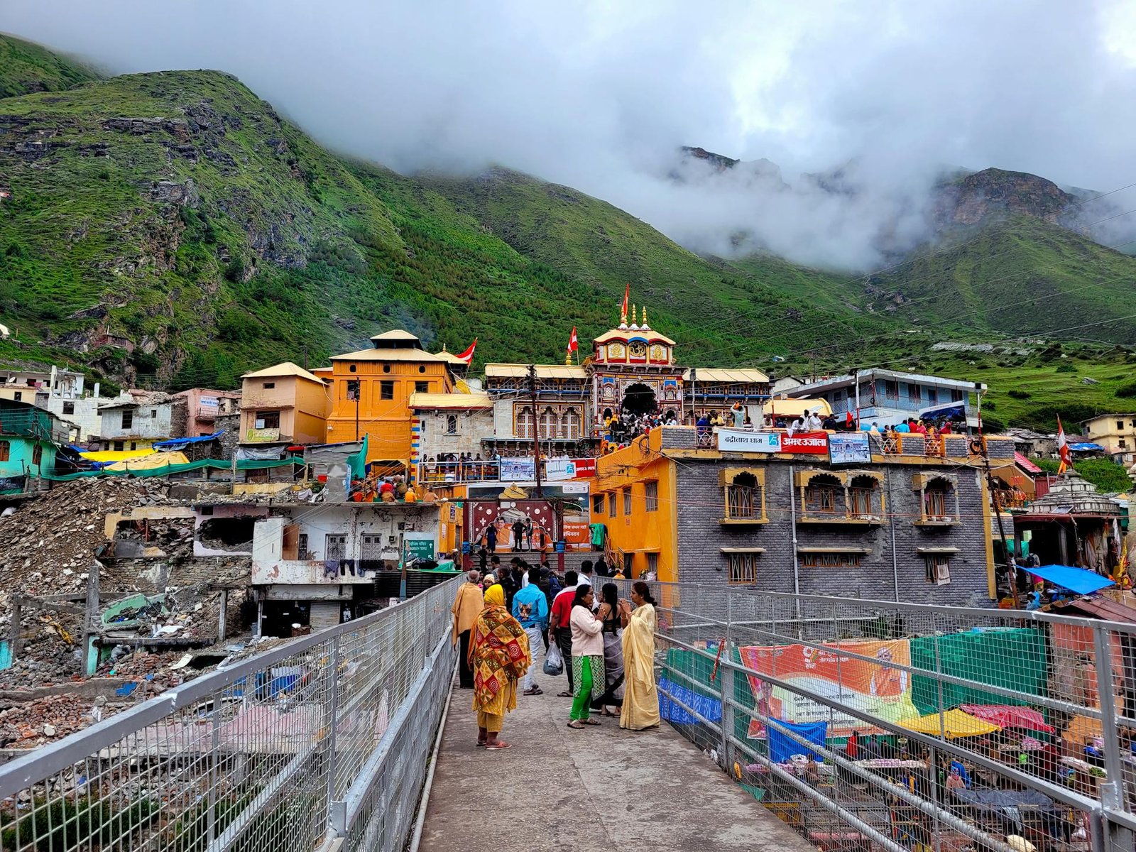
Badrinath Height From Sea Level – Badrinath, one of the holiest destinations in India and a major pillar of the Char Dham Yatra, is nestled in the majestic Garhwal Himalayas of Uttarakhand. Dedicated to Lord Vishnu, the temple attracts lakhs of devotees every year who wish to experience its divinity, natural beauty, and spiritual energy.
One of the most commonly asked questions by travelers and pilgrims is:
What is the Badrinath Height From Sea Level?
The Badrinath Temple is located at an impressive elevation of 3,300 metres (10,827 feet) above sea level. This high-altitude location makes the journey thrilling, scenic, and spiritually uplifting. Due to this significant elevation, the climate remains cold throughout most of the year, and the temple remains open only for six months, typically from May to November.
To help you understand this destination better, here is a complete guide covering the height, climate, trekking conditions, travel tips, and more.
⭐ Badrinath Height From Sea Level – Quick Info Table
| Parameter | Details |
|---|---|
| Badrinath Height From Sea Level | 3,300 m (10,827 ft) |
| Location | Chamoli District, Uttarakhand |
| River | Banks of Alaknanda |
| Best Time to Visit | May–June & September–October |
| Temperature Range | Summer: 5°C–18°C |
| Nearby Attractions | Mana Village, Tapt Kund, Vasudhara Falls, Charan Paduka |
| Route Accessibility | By road via Rishikesh–Joshimath |
| Importance | One of the 108 Divya Desams & part of Char Dham and Chota Char Dham |
Why Is Badrinath’s Height Significant?
The height of Badrinath plays a major role in:
1. Climate & Weather
Because the temple sits at 3,300 m, temperatures remain low even during peak summer. Nights are chilly, while winter brings heavy snowfall, making the region inaccessible.
2. Pilgrimage Challenges
The thin air and steep mountainous routes can make traveling slightly difficult for individuals who are not used to high altitudes. However, with proper rest and acclimatization, the journey becomes comfortable.
3. Scenic Himalayan Beauty
The high elevation allows visitors to witness snow-clad peaks, deep valleys, flowing rivers, and serene landscapes.
The view of Nar and Narayan mountain ranges from Badrinath is truly mesmerizing.
Climate of Badrinath Based on its Elevation
The height directly affects Badrinath’s climatic conditions:
✓ Summer (May–June)
Temperature: 5°C to 18°C
This is the best time to visit Badrinath. Days are cool and pleasant, though nights are cold.
✓ Monsoon (July–August)
Heavy rainfall and landslides are common, making travel risky. Pilgrims avoid this time.
✓ Autumn (September–October)
Clear skies, refreshing weather, and stunning Himalayan views make this another ideal time to travel.
✓ Winter (November–April)
Temperature can drop to -10°C or below. The temple remains closed due to extreme cold and heavy snowfall.
How Badrinath’s High Altitude Affects Travelers
Even though Badrinath is not at extreme altitudes like Leh or Kedarnath, its 3,300 m elevation may still cause:
-
Mild headache
-
Breathlessness
-
Fatigue
-
Dizziness
These symptoms are temporary and can be reduced by:
-
Staying hydrated
-
Taking frequent breaks
-
Avoiding rushing or climbing too quickly
-
Eating light meals
-
Wearing warm clothing
Most pilgrims complete the journey comfortably with basic precautions.
Badrinath Route & Elevation Map Overview
To reach Badrinath, pilgrims usually follow this route:
Rishikesh → Devprayag → Srinagar → Rudraprayag → Karnaprayag → Chamoli → Joshimath → Badrinath
Key Elevation Points:
| Location | Approx Altitude |
|---|---|
| Rishikesh | 372 m |
| Rudraprayag | 895 m |
| Karnaprayag | 1,451 m |
| Joshimath | 1,875 m |
| Badrinath | 3,300 m |
As you move higher, the surrounding views become more breathtaking, and the temperature drops noticeably.
Popular Attractions Near Badrinath (Based on Height & Accessibility)
1. Mana Village (3,200 m)
India’s last village near the Indo–Tibetan border, known for the Bheem Pul, Vyas Gufa, and ancient folklore.
2. Tapt Kund
A natural hot water spring located near the temple. Pilgrims take a holy dip before darshan.
3. Vasudhara Falls (4,000 m)
A beautiful trekking point offering stunning valley views and a peaceful ambience.
4. Charan Paduka (3,380 m)
A sacred rock believed to have Lord Vishnu’s footprint.
5. Neelkanth Peak (6,597 m)
Visible from Badrinath, this snow-covered peak looks magical during sunrise.
Best Time to Visit Badrinath Considering its Height
Due to the extreme cold at higher altitude, the ideal time is:
✔ May–June (Summer)
Comfortable weather, open routes, perfect for elderly pilgrims.
✔ September–October (Post Monsoon)
Clear views and peaceful environment.
Avoid July–August (monsoon) and November–April (winter closure).
Travel Tips for Visiting Badrinath at High Altitude
-
Carry warm woolen clothes even in summer.
-
Wear sports/trekking shoes for comfort.
-
Stay at Joshimath or Pandukeshwar if you need acclimatization.
-
Keep medicines for altitude-related issues.
-
Avoid long breaks during peak cold hours.
-
Check road conditions and weather updates before travel.
If you love reading about travel destinations, elevation facts, tourist spots, and nearby attractions, TopChandigarh.com is a helpful blog offering detailed and reliable regional information. From hill station heights to weekend getaways, temple guides, and local discoveries, the platform simplifies travel planning for readers. Whether you are exploring Uttarakhand, Himachal, or nearby regions, TopChandigarh.com provides easy-to-understand articles that help you make informed travel decisions.