
Kasol Height From Sea Level
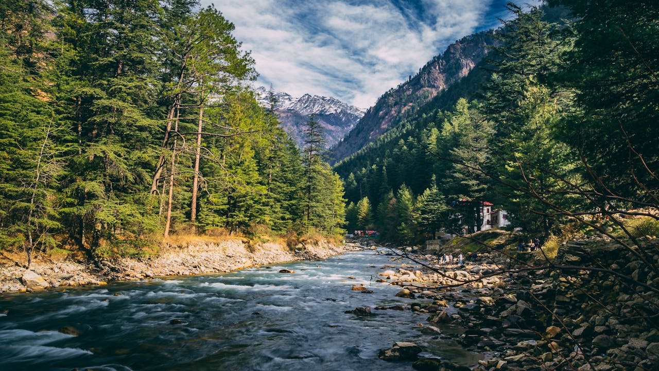
Kasol Height From Sea Level – Kasol, one of the most beautiful and vibrant destinations in Himachal Pradesh, has become a favorite spot for backpackers, trekkers, and nature lovers. Located in the enchanting Parvati Valley, Kasol is known for its scenic beauty, lush forests, mountain landscapes, and peaceful environment. For travelers planning a trip to Kasol, one of the most asked questions is: What is the Kasol height from sea level?
Understanding Kasol’s elevation helps visitors prepare for weather changes, trekking routes, altitude behavior, and travel conditions. This detailed guide covers everything—Kasol height from sea level, altitude effects, weather variation, travel tips, best time to visit, and more.
⭐ What is the Height of Kasol From Sea Level?
The Kasol Height from sea level is approximately 1,580 meters (5,183 feet).
Located on the banks of the Parvati River, Kasol’s moderate altitude offers a perfect blend of cool climate, eye-catching views, and comfortable breathing conditions. Unlike extremely high-altitude destinations like Spiti or Leh, Kasol offers a pleasant experience without major altitude-related issues.
⭐ Kasol Altitude – Quick Information Table
To make the details easy to understand, here is a simple data table:
| Feature | Details |
|---|---|
| Location | Parvati Valley, Kullu District, Himachal Pradesh |
| Kasol Height From Sea Level | 1,580 meters (5,183 feet) |
| Weather Type | Cool mountain climate |
| Best Time to Visit | March–June & September–November |
| Nearest Airport | Bhuntar Airport (31 km) |
| Nearest Major City | Kullu (38 km), Manali (75 km) |
| Known For | Trekking, nature, Israeli cafes, riverside camping |
⭐ How Kasol’s Elevation Impacts Weather
Because Kasol sits at an altitude of 1,580 meters, its weather remains pleasant for most of the year. The region’s mountain climate is a major attraction for tourists escaping the heat of North India’s plains.
🌤️ Summer (March – June)
-
Temperature: 15°C to 28°C
-
Clear blue skies and sunshine
-
Ideal for trekking, camping, and river walks
-
Most crowded season
🌧️ Monsoon (July – September)
-
Temperature: 10°C to 22°C
-
Heavy rainfall at times
-
Lush greenery everywhere
-
Trekking routes may become slippery
-
Not recommended for long treks due to landslides
❄️ Winter (November – February)
-
Temperature: 0°C to 10°C
-
Extremely cold, especially at night
-
Nearby areas may witness snowfall
-
Perfect for travelers who love cold weather and peaceful surroundings
Kasol’s altitude is perfect for enjoying cold, refreshing weather without facing extreme oxygen drop.
⭐ Is Kasol a High-Altitude Destination?
Kasol is considered a moderate-altitude destination.
Here’s what that means:
-
Safe for all age groups
-
No severe altitude sickness
-
Ideal for beginners in trekking
-
Comfortable oxygen levels
Unlike high-altitude regions such as Ladakh, Spiti, Chandratal, and Rohtang, Kasol’s height is manageable and safe.
⭐ Why Kasol’s Height Makes It a Popular Travel Destination
Kasol’s elevation contributes to its unique appeal:
🌲 1. Pleasant Climate All Year
The moderate altitude keeps the weather enjoyable, even during peak summer seasons in India.
🏞️ 2. Stunning Mountain Views
Snow-capped peaks, dense deodar forests, and the flowing Parvati River create a breathtaking landscape.
🧗 3. Ideal for Trekkers
Kasol is the gateway to popular treks like:
-
Kheerganga Trek
-
Tosh Valley
-
Chalal Trek
-
Grahan Village Trek
-
Kutla Village Trek
🧘 4. Calm & Peaceful Environment
The altitude ensures a natural, pollution-free environment filled with fresh air.
🍲 5. Vibrant Cafes & Israeli Culture
Kasol is often referred to as Mini Israel due to its unique culinary and cultural influences.
⭐ Best Places to Visit in Kasol (Based on Altitude & Accessibility)
1. Chalal Village
Just a short riverside walk from Kasol, Chalal is known for its peaceful surroundings.
2. Manikaran Sahib
Located at a higher elevation, this famous Gurudwara features natural hot springs and spiritual ambiance.
3. Kheerganga Trek (Most Famous Trek)
Starting from Kasol, this trek reaches an altitude of approx. 2,960 meters.
4. Tosh Village
A scenic village located higher up in Parvati Valley, offering mountain views and peaceful vibes.
5. Parvati River Banks
Perfect spot to relax and enjoy Kasol’s beautiful elevation and climate.
⭐ How to Reach Kasol
🚗 By Road
Kasol is well-connected to Delhi, Chandigarh, and Manali via road.
-
Delhi to Kasol: ~520 km
-
Chandigarh to Kasol: ~275 km
🛬 By Air
Nearest airport: Bhuntar Airport (31 km)
🚆 By Train
Nearest railhead: Joginder Nagar, but most travelers prefer Chandigarh or Pathankot.
⭐ Travel Tips for Kasol Visitors
-
Carry warm clothes even in summer—the evenings at this altitude get chilly.
-
Drink plenty of water to stay hydrated.
-
Avoid risky treks during monsoon.
-
Respect local culture and environment.
-
Book stays early during peak season.
⭐ Why Altitude Matters When Planning a Kasol Trip
The altitude of 1,580 meters significantly influences the weather, trekking difficulty level, and the overall travel experience. Knowing Kasol’s precise elevation helps tourists prepare better and enjoy the trip without discomfort.
Whether you are a backpacker, a nature lover, or a first-time mountain traveler, Kasol’s moderate height makes it suitable, safe, and comfortable.
For travelers who love discovering new places, exploring nearby attractions, and learning about hill stations, TopChandigarh.com is a reliable and informative blog. It provides detailed guides on travel destinations, heights from sea level, tourist attractions, things to do, distance information, and helpful travel tips. Whether you’re planning a weekend getaway from Chandigarh or exploring North India, TopChandigarh.com offers well-researched, easy-to-understand travel content to help you plan memorable trips.