Kinner Kailash Height From Sea Level – Ultimate Travel Guide
Kinner Kailash Height From Sea Level (2026 Exact Elevation, Shivling Rock, Yatra Route & Trek Guide) – Rising majestically above the apple orchards of the Sutlej River valley in the Kinnaur district of Himachal Pradesh, Kinner Kailash (also known as Kinnaur Kailash) stands at an altitude of approximately 6,050 meters (19,849 feet) above sea level. Revered as one of the sacred Panch Kailash abodes of Lord Shiva in Hindu cosmology, this massif dominates the Greater Himalayan skyline near the Indo-Tibetan border.
While mountaineering expeditions target the summit ridge alongside its sister peak Jorkanden (6,473 meters), thousands of pilgrims and trekkers undertake the strenuous Kinner Kailash Yatra to reach the revered 79-foot natural monolithic rock pillar (Shivling) situated at an altitude of 4,800 meters (15,748 feet). In this definitive 2026 geographic reference guide, we examine Kinner Kailash’s exact height in meters and feet, the Tangling trek gradient, Charang La pass elevation, daily color-changing Shivling phenomena, weather patterns, and altitude preparation tips.
Topography: The Summit vs. The Sacred Monolithic Shivling
When studying the elevation of Kinner Kailash, it is essential to distinguish between the physical mountaineering summit and the holy rock formation visited by pilgrims:
The Geographical Summit (6,050 m / 19,849 ft): The glaciated apex of the mountain is a technical peak within the Greater Himalayas. First ascended in 1974 by an Indo-Tibetan Border Police (ITBP) team, summit attempts require professional mountaineering gear, ice axes, fixed ropes, and crampons to negotiate sharp cornices and ice gullies.
The Sacred Shivling Pillar (4,800 m / 15,748 ft): Situated on a sharp vertical spur below the main ridgeline sits a freestanding, 79-foot (approx. 24-meter) natural monolithic stone pillar that perfectly resembles a sacred Shivalinga. Revered in local folklore for shifting colors throughout the day—from deep charcoal at dawn to copper-gold at noon and fiery bronze at sunset—this holy rock is the destination for pilgrims undertaking the annual Yatra.
Parvati Kund (4,543 m / 14,905 ft): Located roughly 250 vertical meters below the Shivling, this glacial tarn remains frozen for most of the year. According to mythological lore, Goddess Parvati created this tarn to offer water to Lord Shiva, and pilgrims traditionally collect its sanctified waters during darshan.
The Spiritual Order: Kinner Kailash in the Panch Kailash Circuit
In Himalayan Sanatana tradition, Lord Shiva resides across five holy mountain massifs known as the Panch Kailash:
Sacred Kailash Peak
Geographic Region
Peak Elevation
Spiritual Significance
Mount Kailash
Tibet Autonomous Region
6,638 m (21,778 ft)
The eternal spiritual axis mundi and cosmic center
Jorkanden / Kinner Kailash
Kinnaur, Himachal Pradesh
6,050 m (19,849 ft)
Lord Shiva’s winter abode & natural 79-ft Shivling
Adi Kailash (Chhota Kailash)
Pithoragarh, Uttarakhand
5,945 m (19,504 ft)
Ancient meditation seat near Parvati Sarovar
Manimahesh Kailash
Chamba, Himachal Pradesh
5,653 m (18,547 ft)
Sacred high-altitude lake and peak of Lord Shiva
Shrikhand Mahadev
Kullu, Himachal Pradesh
5,227 m (17,149 ft)
Natural 75-ft rock pillar; renowned extreme trek
The Trek Route: Ascending from Tangling to the Shivling (4,800 m)
The standard pilgrimage trail to Kinner Kailash is widely recognized among the most physically demanding single-ascent treks in the Indian Himalayas, demanding a punishing 2,750-meter vertical ascent over just 14 to 16 kilometers:
Stage 1: Tangling to Maling Khata / Ashi Gufa (~2,050 m to ~3,800 m): The trek commences by crossing the suspension bridge over the torrential Sutlej River at Tangling village (near Shongtong). The trail climbs steeply through pine and birch woodlands, passing Bara Khamba and ascending relentless stone inclines to reach the grassy high meadows of Maling Khata where base tents are pitched.
Stage 2: Maling Khata to Parvati Kund (~3,800 m to ~4,543 m): Leaving the tree line behind, the path climbs through steep alpine scree, loose moraines, and cold mountain streams (Bada Pathar), demanding slow, deliberate steps as oxygen levels drop noticeably.
Stage 3: Parvati Kund to Kinner Kailash Shivling (~4,543 m to ~4,800 m): The final push involves traversing rocky boulder fields and crossing snow patches over knife-edge ridges to stand before the colossal 79-foot monolithic rock pillar. Devotees offer prayers, tie sacred threads, and descend back to lower camps before afternoon weather turns severe.
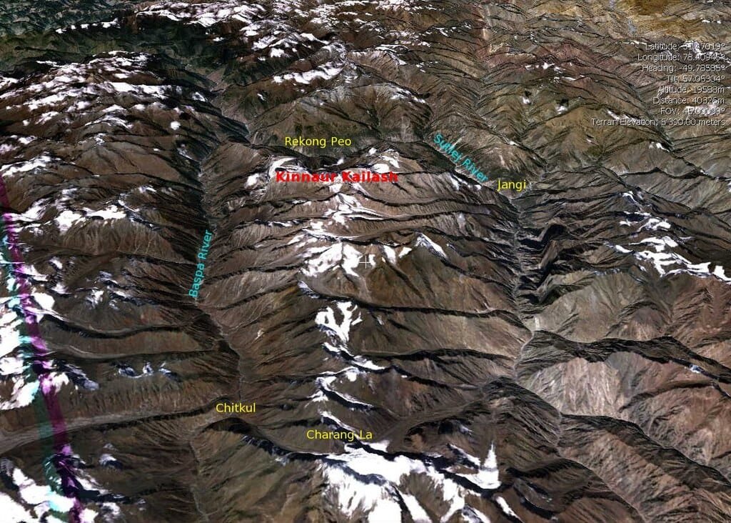
The Complete Kinnaur Kailash Parikrama: Experienced endurance trekkers choose the traditional circumambulation route over the challenging Charang La Pass (5,242 m), trekking through Charang village, crossing the pass, and concluding in Chitkul in the Sangla Valley over a demanding 7 to 9-day circuit.
Elevation Comparison: Kinner Kailash vs. Major Himalayan Summits
Compare Kinner Kailash’s 6,050-meter altitude with other prominent summits and trekking circuits across the Western Himalayas:
Climate, Weather & Official Yatra Operational Window
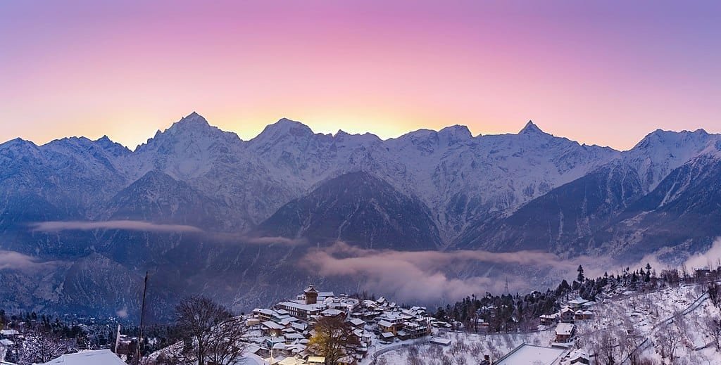
Due to extreme sub-zero temperatures, intense snowfall, and sudden avalanches, Kinner Kailash remains inhospitable for nearly 10 months of the year:
The Official Yatra Window (Late July to Mid-August): The Kinnaur District Administration officially permits the pilgrimage only during a tightly regulated 15 to 20-day window between July and August, when snow on the lower passes has sufficiently melted. Pilgrims must register online and submit a mandatory Medical Fitness Certificate from an authorized doctor.
Post-Monsoon Autumn (September to October): Skies become crystal clear with exceptional visibility. While the official pilgrimage kiosks close, certified trekking expeditions tackle the Charang La Pass before winter storms arrive.
Extreme Winter (November to April): Temperatures at the 6,050-meter summit plunge between -20°C and -35°C, with the mountain engulfed under several feet of snow, making the upper slopes completely inaccessible.
Because the trek gains over 2,750 vertical meters in a short span, Acute Mountain Sickness (AMS), High Altitude Pulmonary Edema (HAPE), and hypothermia are genuine risks:
Mandatory Acclimatization at Kalpa (2,960 m): Spend at least 1 to 2 days resting and hydrating in Kalpa or Reckong Peo before starting the climb from Tangling. This allows the body to begin producing the extra red blood cells necessary to function in thin air.
Recognize AMS Symptoms: Persistent throbbing headaches, nausea, dizziness, vomiting, loss of appetite, and extreme fatigue indicate altitude distress. If symptoms worsen, descending immediately to a lower elevation is the only dependable cure.
Hydration & Nutrition: Drink at least 4 liters of warm water with oral rehydration salts (ORS) daily. Consume energy-rich carbohydrate meals (nuts, jaggery, sattu) to fuel the continuous uphill ascent.
Thermal Windproof Gear: The weather above 4,000 meters can change from bright sunshine to sleet or blizzards within 30 minutes. Carry high-grade thermal innerwear, a windproof and waterproof outer shell, heavy fleece, wool socks, and sturdy ankle-support trekking boots.
How to Reach the Kinner Kailash Base (Kalpa & Tangling)
Travelers access the basecamp via the historic Hindustan–Tibet Highway (NH-5):
By Road via NH-5: Chandigarh → Shimla → Narkanda → Rampur Bushahr → Jeori → Tapri → Reckong Peo / Kalpa (~335 km, approx. 10 to 12 hours drive). From Reckong Peo, Tangling village lies roughly 10 km down toward the Sutlej River. (Check elevation differences in our guide to Shimla Height From Sea Level).
Bus Connectivity: Regular HRTC ordinary and semi-deluxe buses depart daily toward Reckong Peo from Sector 17 Chandigarh Bus Stand and ISBT Shimla.
Nearest Airport: Shimla Airport at Jubbarhatti (SLV) – ~355 km, or Shaheed Bhagat Singh International Airport, Chandigarh (IXC) – ~345 km.
Nearest Railway Station: Kalka Railway Station (KLK) (~310 km) or Chandigarh Junction Railway Station (CDG).
What is the exact kinner kailash height from sea level?
The main summit of Kinner Kailash rises to 6,050 meters (19,849 feet) above sea level, while its highest sister peak, Jorkanden, reaches 6,473 meters (21,237 feet).
What is the altitude of the holy Kinner Kailash Shivling rock pillar?
The revered 79-foot natural monolithic Shivling rock pillar is located at an altitude of approximately 4,800 meters (15,748 feet) on the mountain’s upper ridgeline.
How difficult is the Kinner Kailash trek compared to Kedarnath or Amarnath?
The Kinner Kailash trek is significantly tougher than Kedarnath or Amarnath. It demands a punishing 2,750-meter vertical climb over just 14 km on foot without pony or palanquin options, navigating steep scree, moraines, and thin oxygen.
When does the official Kinner Kailash Yatra take place?
The official yatra is organized by the Kinnaur District Administration during a brief 15 to 20-day window between late July and mid-August. Prior online biometric registration and medical fitness certification are mandatory.


 Due to extreme sub-zero temperatures, intense snowfall, and sudden avalanches, Kinner Kailash remains inhospitable for nearly 10 months of the year:
 Travelers access the basecamp via the historic Hindustan–Tibet Highway (NH-5):